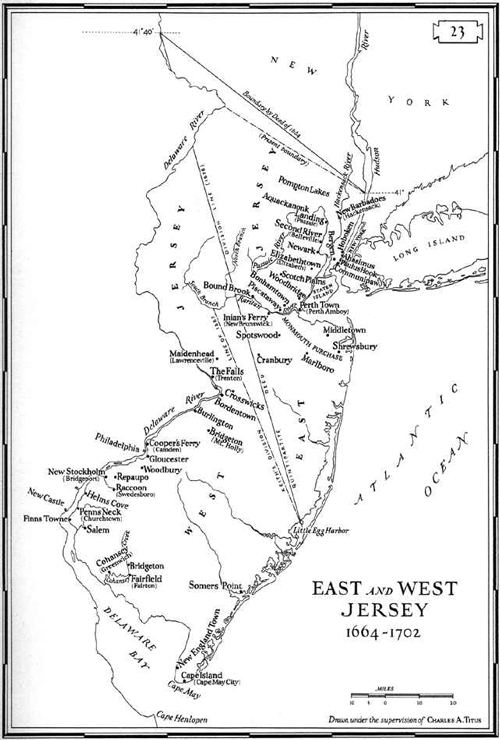
Where was the West Jersey/East Jersey line?
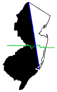
Determination of an exact location for a dividing line was long a matter of dispute, so the better question is "Where were the LINES." A fuller explanation is given below, but for a quick visual introduction (the green line demarcates the "lower eight counties" definition of South Jersey):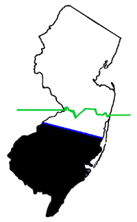
|
|
|
1674 - 1676 The Barnegat - Pennsauken Line was established by grant giving Carteret the northern part of New Jersey. Never surveyed. |
1676 / 1743 / 1855 - present The true line specified by the 1676 Quintipartite Deed between Carteret, Billinge, Penn, Lawrie and Lucas, but not adequately surveyed until 1743. Determined finally, by the New Jersey Supreme Court in 1855, to be the legal line for property settlements (George Cornelius and Christian D. Empson vs. James Giberson, 25 N.J.L. 1; Sup. Ct. 1855). |
1687 This is the first line actually surveyed. The northern third of the survey was not finished as intended, due to the discovery of a major discrepancy from the 1676 Quintipartite Deed. The Keith line was the most operative for County lines in the more populated portions of early West Jersey, however. Because of this, and the fact that this line demarcates the portion that was indisputably West Jersey territory, the Keith line is used throughout this website unless there is specific reason to bring another line into the discussion. |
|
|
|
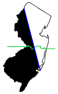
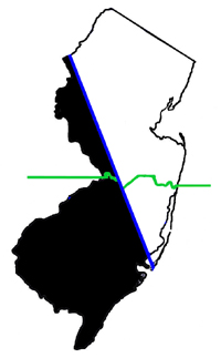
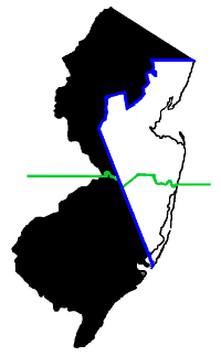
1688-1695 Extension of Keith line reached by compromise between two governors. Disowned by East Jersey in 1695. Abolished by colonial legislature in 1719 in favor of 1676 Quintipartite Deed. |
1775 A line proposed by West Jersey after resolution of New York boundary in 1769. Never adopted. |
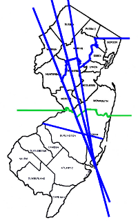
Map showing all lines for comparison, with county names shown. Click here for a large view of this map. |
Of all of these, the 1687 "Keith Line" has been the most meaningful.
Fuller explanation:
The very first mention of a dividing line between Sir George Carteret's half-interest in New Jersey and John, Lord Berkeley's half-interest is in a confirming grant of July 29, 1674 to Carteret only. This specified a southern border for Carteret's land, which ran from the mouth of Barnegat Creek to (most probably) Pennsauken Creek (see the Barnegat - Pennsauken Line).
The East Jersey/West Jersey line was then defined in a 1676 Quintipartite Deed between Carteret and Edward Billinge, (and the three Billinge Trustees: William Penn, Gawen Lawrie and Nicholas Lucas). The Deed described the line as running from... "... the northermost branch of the said bay or river of Delaware, which is in forty one degrees and forty minutes of lattitude, ...., called and agreed to be called the north partition point, and from thence, ... extending southward by a strait and direct line, drawn from the north partition southward, ... unto the most southwardly point of the east side of Little Egg Harbour...."
 The first really operative line was that run by George Keith [1], the Surveyor-General of East Jersey, in 1687.
Remnants of the Keith line can still be seen on today's maps, in the County boundaries between Burlington and Ocean, and between Hunterdon and Somerset. Keith's line favored
East Jersey by running considerably west of the line described in the Quintipartite Deed. It ran NNW from the point on Little Egg Harbor mentioned in the 1676 deed, passing
just north of where Tuckerton is today, and then proceeding up toward a point on the Delaware River just north of the Water Gap (near 41o 01', rather than
41o 40'). Keith stopped surveying when he reached the South Branch of the Raritan, perhaps because West Jersey was disagreeing with his course. Dr. Daniel Coxe, who
had recently claimed title to being goveror of West Jersey, negotiated with East Jersey for a creative way to finish the line (see the Coxe-Keith Barclay line, below).
The first really operative line was that run by George Keith [1], the Surveyor-General of East Jersey, in 1687.
Remnants of the Keith line can still be seen on today's maps, in the County boundaries between Burlington and Ocean, and between Hunterdon and Somerset. Keith's line favored
East Jersey by running considerably west of the line described in the Quintipartite Deed. It ran NNW from the point on Little Egg Harbor mentioned in the 1676 deed, passing
just north of where Tuckerton is today, and then proceeding up toward a point on the Delaware River just north of the Water Gap (near 41o 01', rather than
41o 40'). Keith stopped surveying when he reached the South Branch of the Raritan, perhaps because West Jersey was disagreeing with his course. Dr. Daniel Coxe, who
had recently claimed title to being goveror of West Jersey, negotiated with East Jersey for a creative way to finish the line (see the Coxe-Keith Barclay line, below).
Because the Keith line did not geographically agree with the wording in the 1676 deed, more accurate surveys had to be developed later, to resolve property disputes. This resulted in the Thornton line, c1696, and the Lawrence line, 1743, which is the one used for legal purposes today. An excellent source for learning more about the mapping of New Jersey is Snyder (1973).
Here are some links to maps that show the various lines:
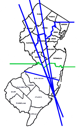
A modern map showing the 1687 Keith line and the 1743 Lawrence line
The 1688 Keith-Coxe-Barclay line which gave a lot more of the north-west part of the Jersies to West Jersey. This was agreed to by Daniel Coxe, who was (considered by some to be) the governor of West Jersey, and Robert Barclay[2] , the governor of East Jersey, but this line did not meet with wide acceptance among the inhabitants due to the shakiness of the claims to the government (see "Who's in Charge Here?"). The Coxe-Barclay extension basically gave present-day Morris and Sussex Counties to West Jersey, though there may have been some adjustments to those borders since 1688. The extension started where the Keith line had left off,
- tracked east, downstream along the South Branch of the Raritan to the split with the North Branch, then
- upstream along the North branch of the Raritan, then
- up the Lamington (or Black) River, then
- jumped by a straight line to the head of the Passaic (see the north border of Somerset County),
- upstream along the Pompton to its split with the Pequannock,
- upstream along the Pequannock, then from a point on the Pequannock at 41 degrees it jumped by a
- straight line due east to the border with New York at the Hudson River Station Point at 41 degrees.
Note that many sources continue the line to the head of the Pequannock, and
thence Northeast (roughly along the current eastern border of Sussex County),
up to New York Boundary Line (which was then also in dispute).
This may have been a compromise used at some time, but the agreement
between Governors Coxe (WJ) and Barclay (EJ) is explicit about the Station
Point on the Hudson.
It is important to remember that there was only a short period of time when both sides agreed with the Coxe-Barclay extension. East Jersey "disowned" it in 1695 and the colonial legislature rescinded it altogether in 1718.
The c1696 Worlidge map showing the Thornton line. This map is located at the West Jersey History Project site which has other maps showing the various lines. A large version with great detail is also available at that site. (Note that the Worlidge line was probably surveyed c1696, but that this map dates from 1706 or later and may have landmarks that were not present in 1696.)
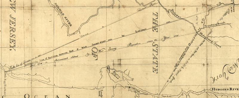
Three (!) lines from Little Egg Harbor on State map of 1780s. This detail is rotated to the right and cropped to show the following three lines.
- "Keith's Line of Division run in 1687 . . . Extended to the Delawar River"
- "Quintipartite Line of Partition between East & West Jersey of 1676 run by Lawrence in 1743"
- "Ideal Line to Mahacomack claimed by West Jersey Proprietors since the Year 1775"
(A full "zoomable" map can be found here, at the Library of Congress map site, though you might have to download the MrSID plug-in to zoom).
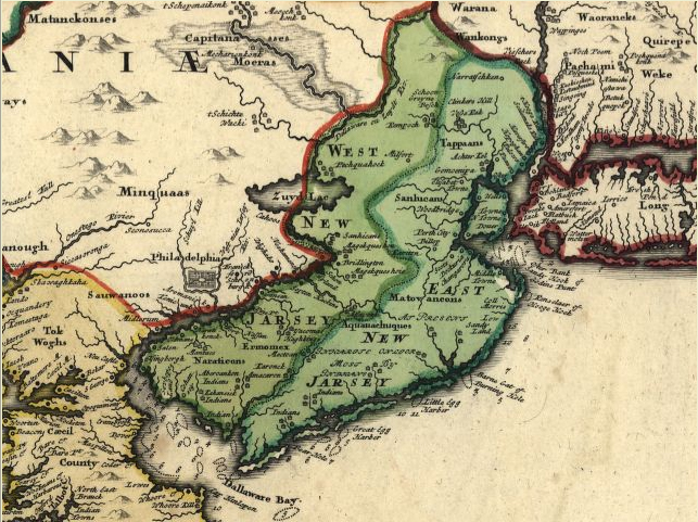
Larger regional maps sometimes drew a West/East line into their maps with rough approximation:
A 1708 map by Moll (detail). Full map can be found here.
A hopelessly inaccurate line, from a 1714 atlas by J. B. Homan (detail, showing a southern terminus in the Delaware Bay!). The full map is available at the Library of Congress website here.
Notes:
1) George Keith is one of the more fascinating characters in the early cultural history of the Jersies. He had been a strong promoter of Quakerism in the British Isles and in Europe. Once in the New World Keith began to criticize Quakers in both the Jersies and in Pennsylvania for straying too far from Christian orthodoxy. Eventually, after forming a group called the "Christian Quakers" and causing a major schism in American Quakerism, he became an Anglican (in 1700) and worked to convert Quakers back to the Church of England. It is notable that, prior to his Anglican conversion, he wrote the second major protest to Quakers against the holding of slaves. (The first protest had been five years earlier (1688) by German Quakers in Pennsylvania).
2) Robert Barclay is famous among Quakers as the first formal Quaker theologian. His "Apology for the True Christian Divinity" is considered a classic. Most Quakers are not aware, however, of Barclay's role as the governor of East Jersey. Barclay never travelled to the New World. He had been an associate of George Keith, who was appointed East Jersey's Surveyor-General, under Governor Barclay.
This site maintained by Bob Barnett.
Last updated: 2015 Twelfth Month, 8th.